


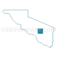
VTD-precinct 13, Charles Mix County, South Dakota
About
Outline

Summary
| Unique Area Identifier | 667107 |
| Name | VTD-precinct 13 |
| County | Charles Mix County |
| State | South Dakota |
| Area (square miles) | 36.34 |
| Land Area (square miles) | 35.44 |
| Water Area (square miles) | 0.89 |
| % of Land Area | 97.55 |
| % of Water Area | 2.45 |
| Latitude of the Internal Point | 43.13414660 |
| Longtitude of the Internal Point | -98.41388090 |
Maps


Graphs
Select a template below for downloading or customizing gragh for VTD-precinct 13, Charles Mix County, South Dakota


Neighbors
Neighoring Voting District (by Name) Neighboring Voting District on the Map
- VTD precinct 1, Charles Mix County, SD
- VTD precinct 4, Charles Mix County, SD
- VTD precinct 5, Charles Mix County, SD
Top 10 Neighboring County Subdivision (by Population) Neighboring County Subdivision on the Map
- White Swan township, Charles Mix County, SD (681)
- Lawrence township, Charles Mix County, SD (543)
- Highland township, Charles Mix County, SD (456)
- Bryan township, Charles Mix County, SD (358)
- Howard township, Charles Mix County, SD (273)
- Goose Lake township, Charles Mix County, SD (145)
- Plain Center township, Charles Mix County, SD (124)
- Kennedy township, Charles Mix County, SD (67)
- Ravinia town, Charles Mix County, SD (61)